Project Overview
The Montana Department of Environmental Quality (DEQ) is conducting water quality studies in the Tongue River watershed, within the portion of the watershed located in the state of Montana (Map 1). This page contains information on a salinity project on the Tongue River itself.

Map 1: Location of the Tongue River Watershed
(Click on map to enlarge)

Tongue River
Photo credit: U.S. EPA, Montana Operations Office
(Click on picture to enlarge)
Why is DEQ Interested in the Tongue River Watershed?
Montana DEQ has determined that a salinity water quality study for the Tongue River is a high priority due to the importance of the Tongue River as an irrigation resource, along with a high level of stakeholder interest and concerns regarding energy development projects. Significant work occurred on this project in the early 2000s, led by the Montana Operations Office of the U.S. EPA, and DEQ is building upon that work. Future water quality projects will also occur to address other identified pollution problems for the Tongue River, Tongue River Reservoir, and tributaries to the Tongue River (Table 1 below); however, these projects have not been scheduled.
What is DEQ’s Water Quality Planning Process?
The state of Montana has established water quality standards for pollutants that may enter and harm our streams, rivers, and lakes. The standards are set to protect beneficial uses that the state has designated for each waterbody; these may include drinking water, recreational uses, agricultural uses, industrial uses, and support of aquatic life. DEQ collects water quality data and compares that data to the water quality standards. Waterbodies that do not meet the standards are determined to be impaired. DEQ then develops solutions for restoring full support of the waterbody’s designated uses. Salinity impairment in the Tongue River is the focus of the project discussed on this page.
Tongue River Project Boundaries and Project Focus
The Tongue River forms in the Big Horn Mountains, west of Sheridan, Wyoming, flows across the Wyoming-Montana state border near Decker, and ends at its confluence with the Yellowstone River in Miles City, Montana (Map 1 above).
The portion of the Tongue River within the state of Montana is divided into seven segments, which are referred to as water quality assessment units (Map 2, Table 1 below). The lowest two segments are listed as impaired for either salinity or specific conductivity in Montana's Water Quality Integrated Report. The segment of the Tongue River from Twelve Mile Dam to the mouth (assessment unit MT42C001_011) is listed as impaired for salinity; the segment above this, Beaver Creek to Twelve Mile Dam (assessment unit MT42C001_014), is listed as impaired for specific conductivity.
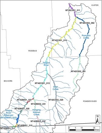
Map 2: Segments of the Tongue River (Water Quality Assessment Units)*
(Click on map to enlarge)
*Assessment units (locations of segment breaks) are determined by Montana DEQ
This project takes the entire area of the watershed into account for determining the sources of salt to the river. DEQ has developed a water quality model for the Tongue River that is being used for source assessments. The Tongue River Salinity Model page provides detailed information on salinity and information specific to how the model is being used. Information on Montana’s salinity water quality standards is contained on the Tongue River Water Quality Standards page.
Table 1: Water Quality Impairments for the Tongue River, Tongue River Reservoir, and Tributaries
|
Waterbody Segment (Assessment Unit)1
|
Assessment Unit ID
|
County
|
Probable Impairment Causes (2020)2
|
|
Tongue River
|
|
Tongue River
Wyoming border to Wyoming border
|
MT42B001_011
|
Big Horn
|
None identified
|
|
Tongue River
Wyoming border to Tongue River Reservoir
|
MT42B001_010
|
Big Horn
|
Iron
Flow regime modification
|
|
Tongue River
Tongue River Dam to Prairie Dog Creek
|
MT42B001_020
|
Big Horn,
Rosebud
|
Flow regime modification
|
|
Tongue River
Prairie Dog Creek to Hanging Woman Creek
|
MT42B001_021
|
Rosebud
|
Flow regime modification
|
|
Tongue River
Hanging Woman Creek to Beaver Creek
|
MT42C001_013
|
Rosebud
|
Iron
Flow regime modification
Sediment
|
|
Tongue River
Beaver Creek to Twelve Mile Dam, T6N, R48E, S29
|
MT42C001_014
|
Rosebud,
Custer
|
Iron
Flow regime modification
Sediment
Specific conductivity
|
|
Tongue River
Twelve Mile Dam to mouth (Yellowstone River)
|
MT42C001_011
|
Custer
|
Cadmium
Copper
Iron
Lead
Flow regime modification
Nickel
Salinity
Sediment
Zinc
|
|
Tongue River Reservoir
|
|
Tongue River Reservoir
|
MT42B003_010
|
Big Horn
|
Chlorophyll-a
Dissolved oxygen
Sediment
|
|
Tongue River Tributaries
|
|
Hanging Woman Creek
Wyoming border to Stroud Creek
|
MT42B002_032
|
Big Horn,
Rosebud
|
Salinity
Flow regime modification
|
|
Hanging Woman Creek
Stroud Creek to mouth (Tongue River)
|
MT42B002_031
|
Rosebud
|
Iron
Salinity
Sedimentation-Siltation
Flow regime modification
|
|
Otter Creek
Headwaters to mouth (Tongue River)
|
MT42C002_020
|
Powder River,
Rosebud
|
Iron
Salinity
Alteration in streamside or littoral vegetative covers
|
|
Pumpkin Creek
Headwaters to Little Pumpkin Creek
|
MT42C002_061
|
Powder River
|
Salinity
Temperature
Flow regime modification
|
|
Pumpkin Creek
Little Pumpkin Creek to the mouth (Tongue River)
|
MT42C002_062
|
Powder River,
Custer
|
Salinity
Temperature
Flow regime modification
|
|
1 See DEQ's Clean Water Act Information Center to view summaries of water quality impairments and full assessment reports.
2 Impairment causes identified in Montana’s 2020 Water Quality Integrated Report
|
Tongue River Project Contacts
See the Tongue River Watershed Project Contacts page for a full description of each project team member's role and for a list of additional contacts.
Page Released: July 6, 2016
Last Updated: May 24, 2023


